

Something new
Started by njm1983, Apr 25 2010 09:02 PM
12 replies to this topic
#1

njm1983
-
- Project Team
-

- 2,867 posts
title available
- Location:Orangevale, California USA
Posted 25 April 2010 - 09:02 PM
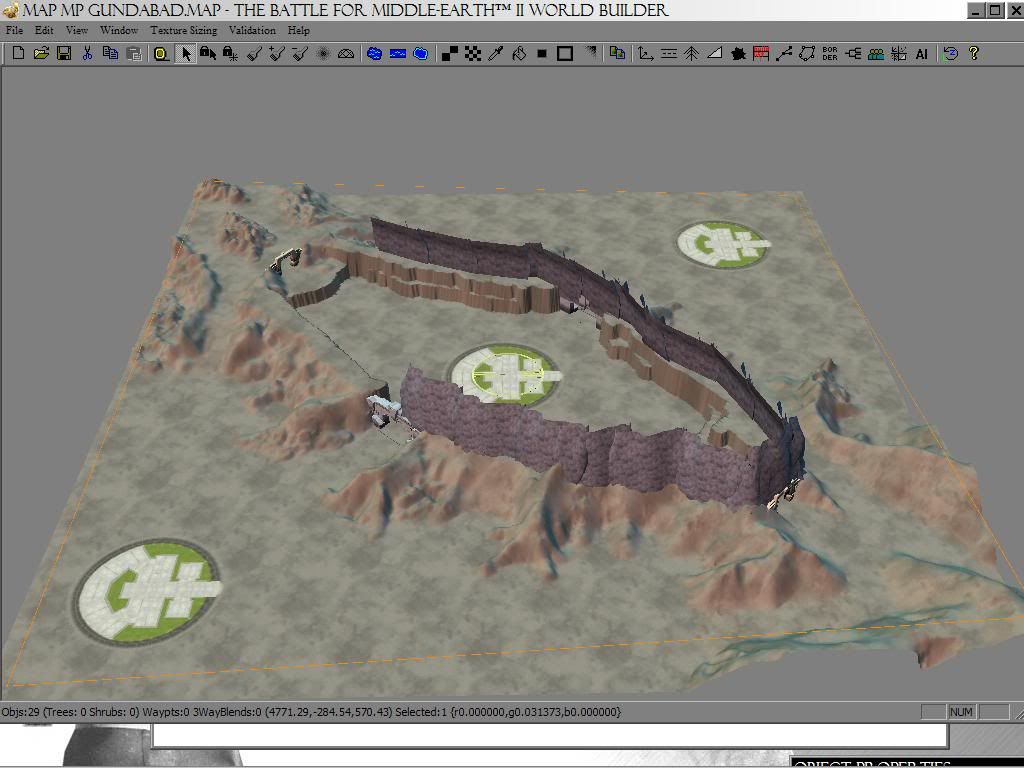
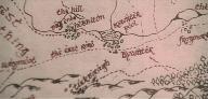
Started to poke around my maps again, and thought id show this off. Not really sure what to call it. I was originally thinking of calling it Gundabad since at one time it was a dwarven stronghold but doesnt feel right. any thoughts?
#2
ttandchotmail
-

- Project Team
-
- 849 posts
title available
- Location:Oz
Posted 26 April 2010 - 01:28 AM
Looks good 
No chance of returning....Zero chance of surviving....Well!? When do we get started?


#3
Arthadan
-

- Members
-

- 215 posts
Posted 27 April 2010 - 06:26 AM
It could be a Dwarven outpost in the Ered Mithrin (Grey Mountains). Tolkien did not write names for them, but I'm sure I can find some names in the old role play game material.
#4
Námo
-

- Project Team
-
- 1,291 posts
***
- Projects:Middle-earth Lore, Cartography & Linguistics
- ...
Posted 27 April 2010 - 12:05 PM
Gundabad = 'Tunneled Mountain' in Khûzdul (Gund is authentic, from the radicals GND, etymology of Abad is from the movie-khûzdul by David Salo).
Considering the low elevation of the cliffs, it would most likely be located in the Iron Hills. If so, you might add some reddish soil (from the etymology of River Carnen 'Redwater' indicating that it carried red sediments from the hills).
The floors from the BfMe1 Gondorian Castle ... are they just some terrain texture, or? - Could you give some hints on your intentions with this map?
Edited by Námo, 27 April 2010 - 12:22 PM.
... elen síla lúmenn´ ómentielvo ...
... a star shines on the hour of our meeting ...
... a star shines on the hour of our meeting ...
#5
khamulrulz
-

- Members
-
- 469 posts
title available
Posted 27 April 2010 - 12:56 PM
i think the gondorian castle thingies are placeholders for where fortresses go... an iron hills fortress map would be cool or it could be one of those outposts in the ered luin, like where thorin stayed in exile before the hobbit..
or it could be one of those outposts in the ered luin, like where thorin stayed in exile before the hobbit..
Edited by khamulrulz, 27 April 2010 - 12:57 PM.
#6
Námo
-
- Project Team
-
- 1,291 posts
***
- Projects:Middle-earth Lore, Cartography & Linguistics
- ...
Posted 27 April 2010 - 08:22 PM
There were two areas of Dwarven Settlements in the Blue Mountains, at the end of the Third Age, remnants of the old Dwarven Strongholds of the First Age.... it could be one of those outposts in the ered luin, like where thorin stayed in exile before the hobbit ...
Thorin's exile was in the northern range of Ered Luin; the area on the eastern side of the mountains, to the north of "Little Lune", was Dwarven territory. The eastern slopes of this part of Ered Luin was rather steep, cf.:
This does not fit with the form of the landscape in the map. However, the map could very well be located in the Ered Luin's southern range:salôn, form listed along with sulûn as a possible name derived from the base S-L-N "fall, descend swiftly" (VT48:24). The derived names are not themselves explained, but would denote something that performs this verbal action. Tolkien was trying to explain the origin of the name of the river Lhûn or Lune, and a Dwarvish origin was among the possibilities listed (a name of such a meaning would fit because "the upper course of the Lune was very steep and swift"). The Sindarin form Lhûn would, within this scenario, presumably arise like this: Salôn or sulûn is borrowed into Sindarin at an early stage, and the first vowel is lost, leaving *slôn or *slûn; this regularly yields Lhûn in later Sindarin.
In the very south of Ered Luin (the part of the mountains to the south of the Gulf of Lune) the range was divided in two lesser ranges, the main one roughly N to S, and the secondary one roughly W to E (shown with some differences in directions in various maps). The area between these two ranges had been Dwarven territory since the First Age, and still was at the end of the Third Age.
These ranges was less high and steep than the northern Ered Luin, so the map could very well be some kind of outpost for this Dwarven realm, either in a pass on the border to Harlindon (Elven country, inhabited mostly by Sindarin Elves) or in a pass leading toward Emyn Beraid (the Tower Hills), the Great East Road and the Shire.
I'll post some more detailed info on this later on in the Lore Forum (references to lore and some cartographic maps).
... elen síla lúmenn´ ómentielvo ...
... a star shines on the hour of our meeting ...
... a star shines on the hour of our meeting ...
#7
njm1983
-
- Project Team
-
- 2,867 posts
title available
- Location:Orangevale, California USA
Posted 28 April 2010 - 01:53 AM
The castle bases are just place holders for the base locations, it helps me space things if I've got a visual references to size and spacing.
My idea with this map is to have it work as 1v1v1 or a 2v1. I like the idea of it being in the iron hills, any specific names to dwarven settlements or strongholds?
My idea with this map is to have it work as 1v1v1 or a 2v1. I like the idea of it being in the iron hills, any specific names to dwarven settlements or strongholds?
#8
Námo
-
- Project Team
-
- 1,291 posts
***
- Projects:Middle-earth Lore, Cartography & Linguistics
- ...
Posted 28 April 2010 - 07:22 AM
If you want an authentic Tolkien name, there is only the well-known "Iron Hills" for the whole area; this is in Westron or Common Speech, no Khûzdul name is given by Tolkien.
You could give it some kind of description in authentic Khûzdul, either "The Hill" (or maybe better "Hill of [the] Dwarves") or "Hill-fortress", the last one could indicate a fortified natural hill-formation. To use such 'names', I think it would be necessary to raise the floor inside the center to give it more an appearance of a hill ... like make it level with the shelf at the NW gate, and make some kind of rampart leading up to the SW and NE gates.
As the map looks now, another possibility in Khûzdul is just "Excavated Hill" ... well, it sounds better in Khûzdul: Shargund or probably more correct Sharaghund ... but this would be right on the limit, and a rather loose interpretation of the root G-N-D.
I really don't like 'inventing' names, or more specific 'proper names'. So, in this case, any name given should be more like just a 'description' in Khûzdul, related to the actual form of the hill in the center. If some naming based on this principle would be helpful, just let me know. 
... elen síla lúmenn´ ómentielvo ...
... a star shines on the hour of our meeting ...
... a star shines on the hour of our meeting ...
#9
Arthadan
-
- Members
-
- 215 posts
Posted 29 April 2010 - 06:43 AM
I really don't like 'inventing' names, or more specific 'proper names'. So, in this case, any name given should be more like just a 'description' in Khûzdul, related to the actual form of the hill in the center. If some naming based on this principle would be helpful, just let me know.
I agree, I think "Iron Hills Outpost" could do fine as name for this map.
#10
njm1983
-
- Project Team
-
- 2,867 posts
title available
- Location:Orangevale, California USA
Posted 29 April 2010 - 09:27 PM
I prefer Tolkien names first, I don't mind names that are created using his languages but first I'd rename a map that's existing and replace it with a better one if no suitable name can be found. So what I'll do is name this map iron hills and rename the current bfme 2 iron hills to something else. Probably Carnen I believe there's a river on it....
#11
ttandchotmail
-
- Project Team
-
- 849 posts
title available
- Location:Oz
Posted 03 May 2010 - 12:09 AM
You could name them north iron hills or south iron hills. I think their was a tolkien word for each corner of the compass but I can't recall them at the moment.
No chance of returning....Zero chance of surviving....Well!? When do we get started?
#12
Námo
-
- Project Team
-
- 1,291 posts
***
- Projects:Middle-earth Lore, Cartography & Linguistics
- ...
Posted 03 May 2010 - 08:23 AM
If a map of the Iron Hills also has the river Carnen on it, the exact place would be Western or rather South-western Iron Hills.
Good proposal, ttandc 
... elen síla lúmenn´ ómentielvo ...
... a star shines on the hour of our meeting ...
... a star shines on the hour of our meeting ...
#13
njm1983
-
- Project Team
-
- 2,867 posts
title available
- Location:Orangevale, California USA
Posted 04 May 2010 - 02:15 AM
Generally speaking you guys are on the right track, Im going to go with a much easier way. Just renaming the original Iron Hills map to: Carnen - with some edits to the water to give it a red hue. This map upon completion will replace the stock one.


0 user(s) are reading this topic
0 members, 0 guests, 0 anonymous users

