Some general info on the topography and geomorphology of the area:
First part of the description in
this post.
The Weather Hills and the Midgewater Marshes:
The sedimentary rock layer, which originally lay on the surface, was exposed to the erosional processes for the longest period of time. Gradually the outer edges of the layer were washed away, until at last the only portion left intact was the remnant towering almost a thousand feet above the surrounding landscape — the Weather Hills. The ridges were barren and rocky, indicating that the bedrock was possibly a flinty limestone, such as in the Flint Hills of eastern Kansas. This permeable stone would have allowed such rapid downward percolation of water that tree growth could not have been supported because of excessive soil aridity. Some of the water, collecting in a crack, could have formed the spring found by Sam and Pippin at the foot of Weathertop.
The underlying layer was less resistant, and its erosion resulted in a lowland. The low gradients there, coupled with continental glaciation that would have disrupted stream courses, left numerous bogs and marshes — the best-known being the Midgewater Marshes.
The Barrow-downs and Bree-hill:
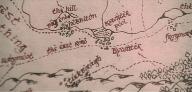
The third group of sediments was relatively resistant. From them were formed the North Downs, Barrowdowns, and the South Downs. Their scarps have been illustrated facing northwest, southwest, and south, respectively — away from the center of the bowl formation. No downlands were shown east of the Weather Hills. Their absence could have been due to any of several variables, including changes in gradient, dip, or rock type.
Only the Barrow-downs were described in any detail by Tolkien. They had no surface drainage and were rather barren, supporting only grasses. Therefore they must have been composed of a highly permeable rock, such as chalk. To visualize the paths trod by the Hobbits, the orientation of the down ridges was of prime importance. Tolkien gave several clues, which had to be integrated:
(1) As the Hobbits led their ponies north away from Bombadil's house, the "hillbrow" was so steep they had to dismount to climb it; yet they were able to ride easily down the gentle slope behind.
(2) Continuing north toward the road, they climbed the steep face and descended the long backslope of ridge after ridge of hills.
(3) When standing atop a hill looking east, the Hobbits could see "ridge behind ridge."
(4) After leaving the hilltop on which they had been fogbound, the Hobbits rode north through a valley.
(5) When Frodo heard cries for help he turned east and went steeply uphill.
Almost all of these references indicate that the down scarps faced south and the ridges themselves ran east-west. The long north-south valley was a series of gaps through the ridges. This orientation, however, conflicts with the circular pattern of downs shown on the map, as well as with processes found in the real world — both of which require the downs to face more to the west. As a compromise, the long axis has been illustrated as trending from northwest to southeast — a reasonable explanation in view of the distinct southwesterly flow of the Withywindle.
Both the barren knob in the Old Forest and Breehill may have been associated geologically with the Barrow-downs. The knob was not far from the east edge of the forest; and when Bombadil guided the four Hobbits to the northwest edge of the downs, he told them they had to go only four miles to reach the Prancing Pony.
History on Andrath in relation to the War of the Ring:
... it is noted that the Black Captain did not know whether the Ring was still in the Shire; that he had to find out. The Shire was too large for a violent onslaught such as he had made on the Stoors; he must use as much stealth and as little terror as he could, and yet also guard the eastern borders. Therefore he sent some of the Riders into the Shire, with orders to disperse while traversing it; and of these Khamûl was to find Hobbiton, where "Baggins" lived, according to Saruman's papers. But the Black Captain established a camp at Andrath, where the Greenway passed in a defile between the Barrow-downs and the South Downs; and from there some others were sent to watch and patrol the eastern borders, while he himself visited the Barrow-downs. In notes on the movements of the Black Riders at that time it is said that the Black Captain stayed there for some days, and the Barrow-wights were roused, and all things of evil spirit, hostile to Elves and Men, were on the watch with malice in the Old Forest and on the Barrow-downs.
Source: Unfinished Tales, The Hunt for the Ring (ii, p. 450-451)
You may find some info on Cardolan
here, though I believe it's of no value for your map, except maybe this:
In 1409, the Witch-king of Angmar sent a great army to attack the Dunedain. [...] The prince of Cardolan was killed, and there was no one left in his line to succeed him. He was buried in the Barrow-downs. Some of the surviving Dunedain of Cardolan took refuge in the Barrow-downs and the Old Forest and held out against the enemy.
In 1636, the Great Plague came north ... many people in Cardolan died, and the Dunedain there were wiped out entirely. The tombs in the Barrow-downs in Cardolan were occupied by evil spirits called Barrow-wights from Angmar.
There are no records in the lore on the location of the capital, but as the Dunedain came close to worship of their ancestors (cf. Rath Dinen in Minas Tirith), various Tolkien scholars have assumed, that it would be situated in the immediate vicinity of the Barrow Downs; hence my previous remark that you eventually could place a few ruins (to the west of the Greenway only).
helpful?